
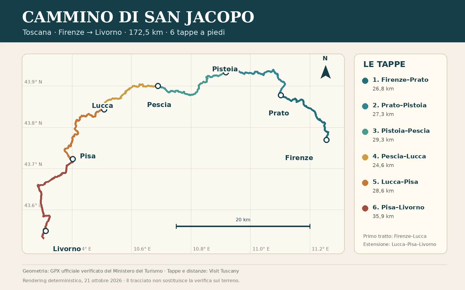
Technical overview of the complete route
Start: Florence. Finish: Livorno. Region: Tuscany. Length published by the official Visit Tuscany portal: 172.5 km. Stages: 6. The portal rates individual days as easy to moderate, but this does not replace your own assessment of distance, surface, elevation gain, weather and fitness.
The official distances of the six stages are 26.8 km from Florence to Prato, 27.3 km from Prato to Pistoia, 29.3 km from Pistoia to Pescia, 24.6 km from Pescia to Lucca, 28.6 km from Lucca to Pisa and 35.9 km from Pisa to Livorno. These figures describe the entire itinerary, not just the four Florence–Lucca stages. The SantiagoLand route page brings together the track and practical information to recheck before departure.
From Florence to Lucca: the first four stages
The first section connects Florence, Prato, Pistoia, Pescia and Lucca. The official itinerary recalls the ancient Cassia-Clodia road connection and crosses art cities, urbanised plains and hilly stretches. It is a cultural journey as well as a walking route: an up-to-date track and signs are still needed for navigation, especially through urban connections.
Pistoia is the historical and spiritual centre. The city has held a relic of Saint James since 1145 and is described by official sources as Santiago minor or Italy's Santiago. After Pistoia, the route continues towards Pescia, through the Valdinievole area, and reaches Lucca. This is the end of the first four-day section, not of the complete Florence–Livorno route.
The extension from Lucca to Pisa and Livorno
From Lucca, the itinerary continues in two stages: 28.6 km to Pisa and 35.9 km to Livorno. Official sources associate this continuation with the ancient Aemilia Scauri route. In Pisa, the walk passes the heritage of Piazza dei Miracoli; approaching the coast, it also reaches the San Piero a Grado area before ending in Livorno at the church of San Jacopo in Acquaviva.
The sixth stage is the longest in the published programme. Before tackling it, check the available official track, resupply points, arrival time and a possible exit plan. Stations along this Tuscan corridor can help you plan alternatives, but services and stops must be checked through the operators' channels for your chosen day.
Preparing for an autumn walk
Daylight hours decrease in October, and rain, wet leaves or mud can slow your pace. This is not a forecast for a particular date: consult weather bulletins and local notices shortly before departure. Choose a manageable stage, download the track for offline use, carry a head torch and protect your phone, documents and dry layers inside your backpack.
Contact accommodation in advance and confirm opening, arrival times and the services actually available. Do not plan a day of almost thirty kilometres, or the 35.9 km Pisa–Livorno stage, around an unconfirmed place to stay. Also check official pages for diversions, works or closures: this article's map reproduces the project's verified GPX track but does not show changes in real time.
Browse accommodation on Italian walking routes ↗Download the practical guides ↗
The pilgrim credential and Jacopea in Pistoia
The pilgrim credential collects stamps and documents the pilgrimage stages. The official Cammino di San Jacopo page explains that, when consulted, there was no credential dedicated exclusively to this route and lists alternative pilgrim documents. Always check application procedures and distribution points before travelling, as these can change.
Anyone who has walked at least 50 km may request the Jacopea in Pistoia under the conditions published by the official route. The named location is the Baptistery of San Giovanni in Corte; it is wise to check days, opening hours and collection procedures in advance. If you start in Florence, keep your stamps and dates in order: the credential is a record of your journey and evidence of the route, not an accommodation booking.